


DATA LIBRARY
SOUTHERN CALIFORNIA DATA (PART I)
[SOUTHERN CALIFORNIA PART II]
Data presented here include a series of remotely sensed images (multibeam, side scan sonar), derived data (bathymetric contours, grid analyses, etc.), habitat analyses, associated data sets (survey footprints, coastline), and FGDC metadata, grouped by survey location. To download zipped data files from the tables, click on the Data Type name under the desired survey location. Data are presented in ESRI ArcGIS format (shapefiles, grids). Multibeam and sidescan images are Geotiffs. These data are NOT to be used for navigational purposes.
For general data searches, use the SURVEY LOCATION LIST or MAP LOCATOR
Please review our Data Use Policy
Data Type |
Data
Format |
File
Size MB (zipped) |
Data
Footprint Preview |
| CA Geology Series- Continental Margin | 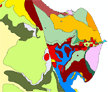 |
||
Shapefile,
polygon |
47 |
||
| ArcGIS(8.3), mxd | 47 |
||
 |
 |
||
GeoTiff(s) |
32 |
||
Shapefile,
polygon |
1 |
||
Shapefile,
line |
<1 |
||
Shapefile,
line |
1 |
||
| GeoTiff | 4 |
||
 |
 |
||
GeoTiff |
4 |
||
GeoTiff |
9 |
||
GeoTiff |
16 |
||
GeoTiff |
6 |
||
GeoTiff |
13 |
||
GeoTiff |
217 |
||
GRID |
13 |
||
GRID |
5 |
||
GRID |
24 |
||
GRID |
<1 |
||
Shapefile,
line |
<1 |
||
Shapefile,
line |
<1 |
||
Shapefile,
polygon |
<1 |
||
GRID |
19 |
||
GRID |
<1 |
||
Shapefile,
point |
<1 |
||
Shapefile,
point |
<1 |
||
Shapefile,
point |
<1 |
||
TXT |
54 |
||
.sd, Iview3D viewer |
50 |
||
Channel
Islands - Santa Rosa Island, South Point |
|
 |
|
GeoTiff |
4 |
||
GeoTiff |
8 |
||
GeoTiff |
217 |
||
GRID |
11 |
||
GRID |
4 |
||
GRID |
17 |
||
GRID |
<1 |
||
Shapefile,
line |
<1 |
||
Shapefile,
polygon |
<1 |
||
GRID |
17 |
||
GRID |
|||
Shapefile,
point |
<1 |
||
Shapefile,
point |
<1 |
||
Shapefile,
point |
<1 |
||
TXT |
34 |
||
.sd, Iview3D viewer |
30 |
||
Channel
Islands - Santa Cruz Island, Gull Island New Data |
|
 |
|
GeoTiff |
1 |
||
GeoTiff |
2 |
||
GeoTiff |
5 |
||
GeoTiff |
6 |
||
GeoTiff |
10 |
||
GeoTiff |
217 |
||
GRID |
14 |
||
GRID |
5 |
||
GRID |
23 |
||
GRID |
<1 |
||
Shapefile,
line |
<1 |
||
Shapefile,
polygon |
<1 |
||
GRID |
17 |
||
GRID |
<1 |
||
Shapefile,
point |
<1 |
||
Shapefile,
point |
<1 |
||
Shapefile,
point |
<1 |
||
TXT |
13 |
||
.sd, Iview3D viewer |
38 |
||
Channel
Islands - Santa Cruz Island, Scorpion Point 2006 |
|
||
GeoTiff |
2 |
||
GeoTiff |
4 |
||
GeoTiff |
2 |
||
GeoTiff |
4 |
||
GeoTiff |
5 |
||
GRID |
15 |
||
Shapefile,
line |
<1 |
||
Shapefile,
polygon |
<1 |
||
GRID |
6 |
||
GRID |
2 |
||
GRID |
1 |
||
Shapefile,
point |
<1 |
||
TXT |
13 |
||
.sd, Iview3D viewer |
21 |
||
Catalina
Island Survey Data from 2001 |
 |
 |
|
GeoTiff |
3 |
||
GeoTiff |
2 |
||
GeoTiff |
1 |
||
GeoTiff |
<1 |
||
GeoTiff |
10 |
||
GRID |
5 |
||
GRID |
2 |
||
GRID |
8 |
||
Shapefile,
line |
3 |
||
Shapefile,
polygon |
<1 |
||
Shapefile,
polygon |
|||
Shapefile,
line |
1 |
||
|
 |
||
GeoTiff |
8 |
||
GRID |
70 |
||
GRID |
34 |
||
GeoTiff |
652 |
||
Shapefile,
line |
>1 |
||
Shapefile,
polygon |
<1 |
||
Shapefile,
polygon |
|||
Shapefile,
point |
>1 |
||
TXT |
54 |
||
Shapefile,
point |
49 |
||
.sd, Iview3D viewer |
<1 |
||
 |
 |
||
GeoTiff |
3 |
||
GeoTiff |
50 |
||
GRID |
11 |
||
GRID |
4 |
||
GRID |
18 |
||
Shapefile,
line |
<1 |
||
GRID |
12 |
||
Shapefile,
polygon |
<1 |
||
Shapefile,
point |
<1 |
||
Shapefile,
point |
<1 |
||
Shapefile,
point |
<1 |
||
Santa
Monica Bay 01_02 Blk14 |
|
 |
|
GeoTiff |
3 |
||
GeoTiff |
24 |
||
GRID |
10 |
||
GRID |
3 |
||
GRID |
16 |
||
Shapefile,
line |
<1 |
||
GRID |
11 |
||
Shapefile,
polygon |
<1 |
||
Shapefile,
point |
<1 |
||
Shapefile,
point |
<1 |
||
Shapefile,
point |
<1 |
||
Santa
Monica Bay 01_02 Blk15 |
|
||
GeoTiff |
4 |
||
GeoTiff |
39 |
||
GeoTiff |
17 |
||
GRID |
14 |
||
GRID |
4 |
||
GRID |
26 |
||
Shapefile,
line |
<1 |
||
GRID |
15 |
||
Shapefile,
polygon |
<1 |
||
Shapefile,
point |
<1 |
||
Shapefile,
point |
<1 |
||
Shapefile,
point |
<1 |
||
Santa
Monica Bay 01_02 Blk16 |
|
||
GeoTiff |
4 |
||
GeoTiff |
20 |
||
GeoTiff |
22 |
||
GRID |
11 |
||
GRID |
3 |
||
GRID |
19 |
||
Shapefile,
line |
<1 |
||
GRID |
12 |
||
Shapefile,
polygon |
<1 |
||
Shapefile,
point |
<1 |
||
Shapefile,
point |
<1 |
||
Shapefile,
point |
<1 |
||
| Santa
Monica Bay 01_02 All Blks |
|||
Shapefile,
polygon |
7 |
||
Shapefile,
polygon |
5 |
||
Shapefile,
polygon |
7 |
||
Shapefile,
polygon |
4 |
||
Shapefile,
polygon |
1 |
||
Shapefile,
polygon |
11 |
||
Shapefile,
line |
<1 |
||
| GeoTiff | 6 |
||
| Shapefile, polygon | 8 |
||
| Shapefiles | <1 |
||
| BMP format | <1 |
||
| Shapefiles | 75 |
||
54 |
|||
 |
 |
||
GeoTiff |
8 |
||
GeoTiff |
16 |
||
GRID |
19 |
||
GRID |
7 |
||
GRID |
34 |
||
Shapefile,
line |
<1 |
||
GRID |
26 |
||
Shapefile,
point |
1 |
||
|
 |
||
GeoTiff |
9 |
||
GeoTiff |
20 |
||
GeoTiff(s) |
79 |
||
GRID |
22 |
||
GRID |
7 |
||
GRID |
38 |
||
GRID |
<1 |
||
Shapefile,
line |
<1 |
||
Shapefile,
line |
<1 |
||
Shapefile,
polygon |
<1 |
||
Shapefile,
point |
<1 |
||
Shapefile,
point |
<1 |
||
Shapefile,
point |
<1 |
||
TXT |
80 |
||
| GeoTiff | 4 |
||
.sd, Iview3D viewer |
81 |
||
Shapefile,
line |
1 |
||
So Cal Data Gap Project 2014: |
 |
||
|
 |
||
GeoTiff |
5 |
||
GeoTiff |
4 |
||
GeoTiff |
43 |
||
GRID |
22 |
||
GRID |
6 |
||
GRID |
31 |
||
Shapefile,
line |
8 |
||
Shapefile,
polygon |
<1 |
||
Shapefile,
polygon |
8 |
||
Shapefile,
line |
<1 |
||
So Cal Data Gap Project 2014: |
|
||
|
|||
GeoTiff |
3 |
||
Shapefile,
polygon |
2 |
||