Project History
2000 The California Marine Habitat Task Force Meeting was sponsored by California Department of Fish and Game, National Ocean Services Special Projects Office, and National Marine Fisheries Service and hosted by California State University Monterey Bay (CSUMB, January 20-21, 2000). Sixty-eight participants representing 38 federal and state marine resource agencies and institutions sharing a vested interest in mapping the marine habitats along the California coast were in attendance. The overall Task Force mission was to build concensus around a Strategic Action Plan for mapping the California continental shelf. The resulting meeting report included tables and maps summarizing the recommendations for high priority sites and data gaps to be mapped, a draft habitat classification scheme, advice on the compilation and processing of existing data, and recommendation on facilitating data sharing.
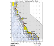
2005 The successful implementation of objectives from the Task Force meeting in 2000 lead to the focused Statewide Marine Mapping Planning Workshop held at CSU Monterey Bay, December 12-13, 2005. The goal of the California Coastal Conservancy-supported workshop was to create a strategic plan for completing the mapping of all seafloor habitats within California State Waters (shoreline out to 3 nmi). The approach was to involve key stakeholders in a gap analysis of existing coverage, identification and ranking of current mapping information needs, the prioritization of areas for new field data acquisition, and the definition of minimum survey and analysis specification required to support those needs. In addition to setting state-wide mapping priorities and standards, the sponsor requested a separate ranking of mapping priorities to support an anticipated RFP for seafloor mapping confined to the state waters extending from Monterey Bay north to Bodega Bay, known as the North Central Coast Mapping Project (NCCMP Phase 1). During the Strategic Planning Workshop, participants ranked all state waters between Stinson Beach and Año Nuevo as the highest priority area in need of mapping along the Northern Central California Coast (Monterey to Bodega Bay).
Progress: Idea to Implementation
 Marine Habitat Task Force Workshop - 2000 Attendees identified major gaps in exisiting marine data, a common interest in acquiring general habitat information, and laid the groundwork for developing an informal communication network between agencies statewide. More...
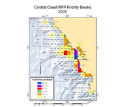 Strategic Planning Workshop - 2005The concensus at the workshop was that the minimum unversal seafloor mapping information for California should cover all "lands" from the shore strand line (MHHW) out to the 3 nautical mile state water limit.. More...
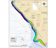 Statewide Mapping - Phase I & II The nearshore mapping of high priority habitat areas (as defined by the previous marine mapping workshops) began in 2007 with the north-central coast region and moved northward based on the data needs of the MLPA process. More...
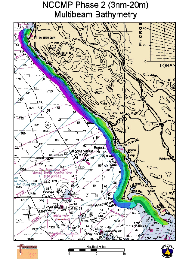
2006 In 2006, the Ocean Protection Council (OPC) authorized the California Coast Conservancy to fund the proposed work by the (now CSMP) partners to begin mapping the areas from MHHW to 3 nmi between Ano Nuevo and Bodega Bay (NCCMP Phase I map | data ). Supplemental funding was also contributed by the California Department of Fish and Game to complete this coverage. Later that year, the NCCMP Phase II was implemented when the project was further augmented by OPC to extend the coverage from Bodega Bay north to Point Arena from the 3nm state waters limit into the 20m isobath (map).
2007 In October 2007, the OPC approved $15m in bond funding for completion of the CSMP data collection along the California mainland (staff report PDF).
2008 CSMP field work commenced in spring 2008 and continued until December 18th 2008 when a Governor-ordered State funding freeze in response to California’s financial crisis halted all work on state bond-funded projects.
2009 - ? The Coastal Conservancy resumed funding for various CSMP elements in May with a full resumption of data collection activities by July 2009. This temporary restart is scheduled to continue through the end of the calendar year. Progress beyond 2009 will depend upon the availability of funds.
2010-12 Marine habitat surveys continued in the South Central Coast (SCC) region between Piedras Blancas and Point Arguello, and also south of Big Sur (BSS) from Lopez Point to Point Sierra Nevada.
2012 Produced a 36 page glossy booklet highlighting CSMP Central Coast Marine Protected Areas (design graphics by Amadeo Bachar)
2013 Summary of CSMP presented at State of the California Central Coast symposium.
Completion of and lessons learned from the 6000 km2 California Seafloor Mapping Project, Dr. Rikk Kvitek (presenter)
2012-14 San Nicolas Island (2012), San Clemente Island (2013), and data gaps between Dana Point and Imperial Beach (2014, Southern California Data Gaps project) have been mapped and processed by SFML.
 Map generation products follow a 3-tiered approach-- from basic survey data to highly detailed habitat classification.
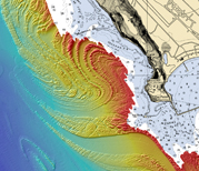 Maverick's - Half Moon Bay, CA