CSMP Technology
The Primary Tool: Multibeam Echo Sounder (MBES)
The basic original data being collected for the CSMP is acoustic, also known as sonar data. The specific type of sonar used for virtually all of the new mapping conducted for CSMP is the multibeam echo sounder, or MBES. Multibeam sonar provides high-density, high-resolution measurements of ocean depth and bottom reflectivity across a wide swath of the seafloor on each pass of the survey vessel. By driving the vessel back and forth over an area in a pattern similar to mowing a lawn, 100% coverage of the seafloor can be achieved, with nearly every feature, nook, and cranny imaged, from a house-sized boulder down to a cobble the size of a basketball.
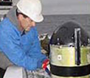
The CSMP employs RESON Seabat™ multibeam sonars for nearly all new mapping surveys. These include the RESON Seabat™ 8101 (240 kHz), 8111 (100kHz), 7125 (200 & 400 kHz) and 7111 (100 kHz) MBES systems, with the specific model used being dependent on the depth range of the area and maximum depth of the seafloor at the state waters boundary. These state-of-the-art MBES systems, calibrated via NOAA standard patch test methods, provide comprehensive seafloor topography (also called bathymetry) and imagery with resolution and accuracy that was previously unobtainable, for the entire state waters of California.
RESON Seabat™ sonars are providing the basic raw data being used by CSMP to define topographical features such as sediment interfaces, rock outcrops, and important seafloor habitat.
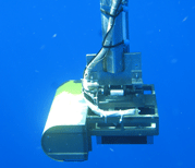
The Seabat™ 7125 is being used for the shallowest areas along our coast, primarily from 0-200m depth. Within this range, the higher frequency (400 kHz) is used for the very shallow areas, and the lower frequency (200 kHz) on the deeper end. The Seabat™ 7125 receiver covers a 128° swath, with ultra high resolution and a maximum range of 300m. The Seabat™ 7125 is capable of equi-distant or equi-angular beam spacing across the entire swath to provide uniform sounding density and maximize usable outer swath. The Seabat™ 7125 receiver sonar head design provides increased bandwidth, improved dynamic range and noise immunity over earlier models and makes full use of Commercial-off-the-Shelf (COTS) hardware and software to increase cost effectiveness with a well defined path for future upgrades and expansion.
The deeper parts of California's state waters, down to 1200m or more, are being mapped with the RESON Seabat™ 8111 and 7111 sonars. The Seabat™ 7111, operating at 100 kHz, has a total receive sector of 150°, within which equi-distant or equi-angluar soundins may be collected (the 8111 has the same frequency and coverage but may collect only equi-angular soundings). This wide receive sector of the 8111/7111 results in a swath coverage of up to seven times the depth of the water, maximizing efficiency and reducing costs. For example, in 400m of water, a swath almost 3 km across is mapped! Deeper-water MBES systems are by necessity larger and more cumbersome, but the Seabat™ 7111 and 8111 are among the most compact and portable systems capable of reaching the depths required under CSMP.
In addition, SEA SWATHplus™ interferometric sidescan bathymetric sonar is being used to augment the RESON multibeam systems, especially in extreme shallows (<10 m) where the superior depth to coverage ratio of interferometric sidescan enables more efficient and cost effective survey operations.
 Map generation products follow a 3-tiered approach-- from basic survey data to highly detailed habitat classification.
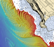 Maverick's - Half Moon Bay, CA