header image left header image right

SFML MAP GALLERY

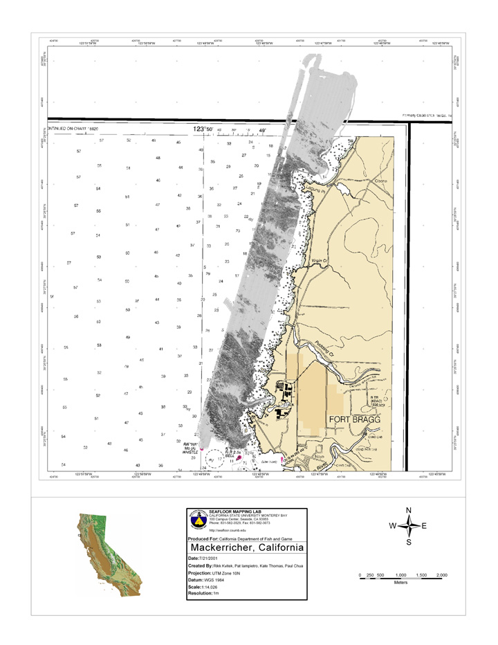
Example imagery from various multibeam survey projects produced through the Seafloor Mapping Lab. Full extent and closeup views of shaded relief grayscale and depth-colored multibeam bathymetry are included in a layout format. The bottom row images include a selection of research posters displayed at various local and international conferences. Click on thumbnail for a larger view.

Note, the imagery displayed here is not to be used for navigation. See Data Library page for access to SFML survey data, or contact Pat Iampietro or Carrie Bretz if you are interested in obtaining the original images or associated data not currently available on-line. Data includes FGDC-compliant metadata.


Mackerricher State Reserve, Northern California Point Cabrillo, Northern California Bodega Bay, Northern California Point Arena, Northern California Humboldt Bay multibeam bathymetry, colored by depth     Terra Nova Bay, ANTARCTICA- ASPA Boundary (proposed) Terra Nova Bay, ANTARCTICA- multibeam 25m color contours Terra Nova Bay, ANTARCTICA-multibeam image
Cordell Bank National Marine Sanctuary: multibeam bathymetry, colored by depth     Neck Point, San Juan Channel, Washington State Pile Point, Haro Strait, San Juan Islands, Washington State Olympic Coast National Marine Sanctuary, Washington State
Monterey Bay Canyon Head, Central California Moss Landing- Monterey Bay Canyon Head Delmonte Shalebeds 1, Monterey Bay, Central California Delmonte Shalebeds 2, Monterey Bay, Central California Cruise ship anchorage project-Delmonte Shalebeds, Monterey Bay, Central California Elkhorn Slough 1- erosion & sedimentation cross sections, Central California Elkhorn Slough- shaded bathymetry, Central California Yankee Point, Big Sur coast: multibeam Yankee Point, Big Sur coast: multibeam colored by depth Soberanes Point, Big Sur coast: multibeam Soberanes Point, Big Sur coast: multibeam colored by depth
Kaslers Point, Big Sur coast: multibeam Kaslers Point, Big Sur coast: multibeam colored by depth Hurricane Point, Big Sur coast: multibeam Hurricane Point, Big Sur coast: multibeam colored by depth Big Sur Coast: 2004 survey coverage San Francisco Bay mouth, 2004 & 2005 survey San Francisco Bay mouth, 2004 & 2005 survey Carmel Bay multibeam colored by depth Hurricane Point, Big Sur coast (2005): multibeam colored by depth Point Sur, Big Sur coast (2005): multibeam colored by depth Cooper Point, Big Sur coast (2005): multibeam colored by depth
Morro Bay, multibeam bathymetry, colored by depth Pillar Point Harbor : multibeam bathymetry, colored by depth Mavericks Surf 07 Maverick's 07 color image Monterey Peninsula coverage 2001-06 Big Sur coverage 2001-06 North Central Coast Mapping Project_ Phase 1 coverage
Catalina Island, Southern California La Jolla, San Diego, Southern California Tanner Bank, offshore, Southern California Point Vincente, Santa Monica Bay, Southern California Palos Verdes Point, Santa Monica Bay, Southern California White Point, Santa Monica Bay, Southern California Kelp loss assessment-Palos Verdes Point, Santa Monica Bay, Southern California Gull Island, Santa Cruz Island, Channel Islands, California: multibeam Gull Island, Santa Cruz Island, Channel Islands, California: multibeam Gull Island, Santa Cruz Island, Channel Islands, California: rocky habitat Gull Island, Santa Cruz Island, Channel Islands, California: slope analysis
Gull Island, Santa Cruz Island, Channel Islands, California: side scan sonar imagery Carrington Point, Santa Rosa Island, Channel Islands, California: multibeam Carrington Point, Santa Rosa Island, Channel Islands, California: mulitbeam Carrington Point, Santa Rosa Island, Channel Islands, California: rocky habitat Carrington Point, Santa Rosa Island, Channel Islands, California: rugosity analysis Carrington Point, Santa Rosa Island, Channel Islands, California: slope analysis Carrington Point, Santa Rosa Island, Channel Islands, California: analyses buffers Carrington Point, Santa Rosa Island, Channel Islands, California: side scan sonar imagery South Point, Santa Rosa Island, Channel Islands, California: multibeam South Point, Santa Rosa Island, Channel Islands, California: multibeam South Point, Santa Rosa Island, Channel Islands, California: rocky habitat
South Point, Santa Rosa Island, Channel Islands, California: rugosity analysis South Point, Santa Rosa Island, Channel Islands, California: slope analysis South Point, Santa Rosa Island, Channel Islands, California: analyses buffers South Point, Santa Rosa Island, Channel Islands, California: side scan sonar imagery San Clemente Island, multibeam bathymetry, colored by depth San Clemente Island, multibeam bathymetry, shaded relief San Clemente Island, rugosity analyses San Clemente Island, slope analyses
ECOHAB- Sea Otter Behavior & Prey Toxicity: Research Conference Poster (PDF) Olympic Coast National Marine Sanctuary, WA: Research Conference Poster (PDF) ECOHAB- PSP & Sand Crabs: Research Conference Poster (PDF) Spatial Data Modeling Tool: Research Conference Poster (PDF) Santa Monica, CA Habitat: Research Conference Poster (PDF) ECOHAB- Domoic Acid & Sand Crabs: Research Conference Poster (PDF) ECOHAB- Shorebird behavior & Prey Toxicity: Research Conference Poster (PDF) Cailfornia and the World Ocean Conference 2006, Seafloor Mapping Lab Poster (PDF) Elkhorn Slough Research Symposium, 2007    
North Central Coast california State Waters Mapping Project Santa Monica Bay Nearshore Habitat Mapping Project Poster (PDF), State of the Bay Conference 2005 GIS Terrain Analysis: Research Conference Poster (PDF)    


SFML Home | Capabilities | Projects | Partners | Contact Us | Data Library


Go to SFML Main PageGo to CSUMB Main Page Go to SFML Main PageGo to CSUMB Main Page